West Highland Way
This is the West Highland Way Page. It features an interactive map that is intended to help anyone planning a hike along the walk to plan the each days walking. To this end the path is clearly marked with alternating red and orange sections. Each section is 1 mile long.
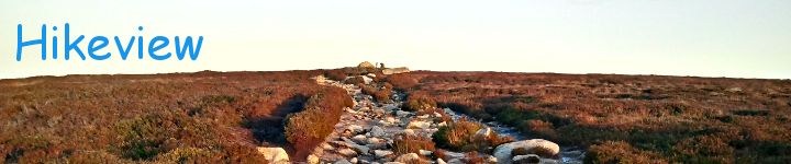
Here are some photos of the type of scenery available on the walk added here with the permission of the photographer Justin Willerton.
Planning a walk on the West Highland Way The West Highland Way Trail starts in Milngavie on the northern outskirts of Glasgow, and ends at Fort William in the Highlands, covering total distance covers 95 miles. The convention is to walk from Souoth to North, but plenty of walkers choose to start in Fort William and work their way South. The start and end points of the West Highland Way are both accessable by rail, both via Glasgow. There is also a bus service from Glasgow to Fort William (and presumably the other way too) which takes about 3 hours.
Standard Sections The trail is typically divided into the following sections, each section representing a day’s walking. There is obviously no obligation to stick to this breakdown, and with this in mind the map below indicates the trail in one mile sections (alternating red and orange lines). This allows you to quickly choose a day’s walking by counting sections up to the distance you feel comfortable with.
Milngavie to Drymen Starting at Milngavie (55m) the trail heads north through a wooded pathway and out to Mugdock Wood (117m) and out to open moorland by Craigallian Loch (138m). The trail then peaks at 140m just beyond Carbeth Loch and then descends steeply to skirt around Dumgoyne Hill (36m). The surroundings remain fairly flat and pastoral for the next 5 miles, passing through fields, lanes and plantations, before climbing slightly to the A811 just outside Drymen (65m). 11.8 miles, cumulative ascent S-N:275m Cumulative ascent N-S:265m Walking time estimate S-N: 4.5 hours N-S: 4.5 hours
Drymen Rowardennan From Dryman the trail climbs quickly to Garadh Ban Wood (169m) where it turns West. Exiting the wood the path peaks at 190m, drops slightly to cross the Burn of Mar before climbing steeply up Conic Hill, missing the peak to reach the max altitude of this section at 319m. The path then descends steeply to the shore of Loch Lomand (20m) which it follows at a fairly flat level (much parallel to the road) for 8 miles to Rowardennan. 14.2 miles, cumulative ascent S-N:652m Cumulative ascent N-S:693m Walking time estimate S-N: 5 hours 45 mins N-S: 5 hours 50 mins
Rowardennan to Inveraran From Rowardennan the path passes through the car park close to the Pier through Oak woodland, still quite close to the shoreline. After about 2 miles the path veers away from the shore (there is an option to remain closer, but the going is fairly tough). At this point the trail climbs steeply to 145m only to undulate down to the shoreline again (26m) and continue through wooded paths to Inversnaid (17m). The terrain opens up a bit now, continuing along the shore to the North end of the Loch where a brief climb over a hill by Dubh Lochann (99m) brings you to the campsite across the Fallocj from Inverarnan (18m). 13.8 miles, cumulative ascent S-N:611m Cumulative ascent N-S:617m Walking time estimate S-N: 5 hours 45 mins N-S: 5 hours 45 mins
Inveraran to Tyndrum This section starts with a long climb over 6.5 miles from the campsite though moorland close to the A82 and the River Falloch to 335m in the woods around Kirk Crag. From here the path descends through the woodland, to cross railway, A82 and the River Fillan (166m) and enters slightly more pastoral territory. From here the way has a gradual climb to Tyndrum (239m). 12 miles, cumulative ascent S-N:551m Cumulative ascent N-S:330m Walking time estimate S-N: 4 hours 55 mins N-S: 4.5 hours
Tyndrum to Inveroran Leaving Tyndrum the path follows an old military road close to the A82, climbing steadily to 330m over 1.7 miles where the A82 swings away and the path descends shaply to skirt around Auch (201m) before continuing in the military road to the Bridge of Orchy (155m). The path climbs briefly through a woodland and then out onto open mountain to a peak of 331m where it descends sharply to Inveroran (179m). 8.84 miles, cumulative ascent S-N:313m Cumulative ascent N-S:372m Walking time estimate S-N: 3.5 hours N-S: 3.5 hours
Inveroran to Kings House From Inveroran follow the road down to Victoria Bridge and Forest Lodge where a steady climb past a plantation out onto the moorland to 330m 3.75 miles in. The level drops slightly (300m) and rises again over about 2 miles to just beyond Ba Bridge when a steady climb to 446m over 1.25 miles followed by a 3 mile descent, crossing the A82 into Kings House (245m). The landscape is open and isolated moorland and the walker is warned to to stray from the path due to peat bogs. While an easy walk it is a very challenging spot in bad weather. 10 miles, cumulative ascent S-N:319m Cumulative ascent N-S:252m Walking time estimate S-N: 3 hours 50 mins N-S: 3 hours 45 mins
Kings House to Kinlochleven From Kings House the route is fairly flat as far as Altnafeadh (294m) when it starts a steep zig-zag climb up the Devil’s Staircase to the shoulder of the hill (548m). After this the rest of this section is a slow undulating descent over 5 miles to Kinlochleven (13m). 9 miles, cumulative ascent S-N:437m Cumulative ascent N-S:670m Walking time estimate S-N: 3 hours 45 mins N-S: 4 hours 10 mins
Kinlochleven to Fort William This day is one big hump, starting with a steep zig-zag climb through woods out of Kinlochleven reaching 245m after 1.75 miles. Walking on the old military road through Lairigmor the highest point of the day (332m) comes after another 2 miles. From here the route descends steadily, after a while swinging north to pass through a woodland (190m). This bringsback the climbing with 3 hills in 3 miles, the highest at the end emerging from a woodland (277m) and then descends sharply (if not directly) towards Glen Nevis Caravan Park (16m), joining the C1162 shortly after the park which is then followed the rest of the way into Fort William (16m). 16 miles, cumulative ascent S-N:632m Cumulative ascent N-S:630m Walking time estimate S-N: 6 hours 20 mins N-S: 6 hours 20 mins
Accomodation Having decided how far you want to walk on a given day (taking into account the terrain descriptions given above) the next thing to do is arrange accomodation. The trail passes through or close by numerous villages and towns, and the excellent West Highland Way homepage is a great resource for identifying potential places to rest weary bones at the end of each day. Bags While the trail is not too hard going it is far more pleasant to leave the heavy lifting to someone else, and a couple of services exist to help in this regard. Again I will direct you to the baggage transport section of the West Highland Way homepage.
❮ ❯